You are here
Palaeolithic settlement, geoarchaeology of Wadi Hasa in Southern Levant
By Saeb Rawashdeh - Oct 24,2024 - Last updated at Oct 24,2024

A view of Wadi Al Hasa , located between Karak and Tafileh governorates (Photo courtesy of ACOR)
AMMAN — Located between the Karak and Tafileh governorates, Wadi Hasa was of interest for Jordanian and foreign researchers who from the late 1960’s conducted series of interdisciplinary human ecology projects. Some of these projects studied regional models of Palaeolithic adaptation and environmental change in the southern Levant. Some areas in Nile Valley, Sinai Peninsula and Wadi Araba were studied in the past 50 years.
“A first attempt to structure relationships between archaeological sites and landforms in the Wadi Hasa was made in the early 1960’s,” noted the professor Geoffrey Clark from Arizona State University, adding that it has been periodically revised as Levantine prehistoric geography and has been updated, but remains grounded on isolated associations between terrace remnants and very limited numbers of presumably diagnostic artefacts.
"Until now, only a single radiocarbon determination has dated upper levels of the lowermost [5 m] terrace of the present wadi. The terrace was designated a chrono-stratigraphic marker whose aggradations began about 8,000 years ago. Systematic archaeological investigations in the Wadi Hasa were initiated in 1979, and identified a total of 1074 sites, over 25 per cent of which were pre-ceramic," Clark explained.
More intensive investigations of selected Palaeolithic sites were pursued since 1984 when it was found that temporally diagnostic stone tool industries were preserved in lake, stream, spring and slope deposits that also contained dateable organics and tufas, Clark continued adding that apparent lacustrine sequences combined with prehistoric site elevation and distribution patterns hinted that site-landform complexes analogous to those of the western Rift were preserved well into the interior.
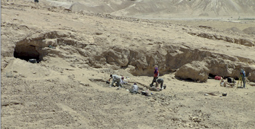
"Accordingly, in 1984 and 1992 detailed geo-archaeological studies were undertaken at four Upper Pleistocene sites selected because they preserved integrated natural and cultural stratigraphies. The sites include a Middle Palaeolithic open occupation (WHS 621) and adjacent Upper and Epipalaeolithic sites (WHS 618 and 1065, respectively)," said Joseph Schulderlein, an expert in geo-archaeology, adding that in contrast with the Wadi Hasa’s south-north flow across the lake basin, the drainage downstream of the fault is east to west and terrain is characterised by steeper landscape gradients and a narrower, confined valley.
Geo-archaeological research in the Wadi Hasa is beginning to yield a baseline Late Quaternary chronology for the southern Levant east of the Jordan Rift Valley, Schulderlein said, adding that previously the vast desert terrain extending across the Jordanian Plateau and eastward to the Arabian Peninsula had been only marginally investigated by scientists.
"For the Wadi Hasa, associations between sealed archaeological deposits, landforms, and environmentally diagnostic strata and sediments have been keyed to a series of radiocarbon dates to develop a palaeo-landscape succession, "Schulderlein pointed out, adding that this succession spans early Middle Palaeolithic through late Holocene time frames and facilitates reconstructions of prehistoric occupation and preservation settings.
Wadi Hasa encompasses an area of ca. 1740 kilometres square and empties into the Dead Sea – Wadi Araba ca. 60 km northwest of the study area.
"Numerous first-, second-, and third-order streams feed into the trunk stream over its course, but they are most extensive and graded in the eastern segment of the drainage ['Upper Hasa']. Here, water recharges the drainage net through a series of aquifers flowing along impervious [Upper Cretaceous] limestone bedrock," Clark said, adding that local landscapes are dominated by a lake plain with dissected surfaces preserved at elevations up to 815 metres.
The valley widths in the area range between 0.2 and 1.0 km. As Schulderlein noted, downstream of the Hasa Fault, the northern and western segment of the drainage (“Lower Hasa,” near WHS 634) traverses considerably steeper terrain whose hydrography was initiated by Eocene tectonic movements.
"The Lower Hasa is incised through a narrow alluvial terrace plain flanked by an over steepened piedmont and bedrock valley. The Upper Hasa forms a lake plain that has been in filled by Late Quaternary sediments analogous to those accumulated in depressions west of the Rift. Research on both sides of the Rift
Valley has demonstrated that the initial basins were formed by repeated fault and related movements," Clark underscored.

Related Articles
AMMAN — Wadi Hasa is one of the most southern wadis between the Dead Sea and the Central Plateau.
AMMAN — The projects dedicated to the Prehistory of Jordan became prominent in the last 30 years, showing an increased academic interest by
AMMAN — On a terrace high above the lower Wadi Al Hasa in central Jordan, two game boards were found at an archaeological site, shedding lig

Opinion

Dec 17, 2024

Dec 17, 2024
Dec 17, 2024
- Popular
- Rated
- Commented
Dec 17, 2024
Dec 17, 2024
Dec 17, 2024


Dec 17, 2024
Newsletter
Get top stories and blog posts emailed to you each day.