You are here
Monster Hurricane Ian hammers Florida
By AFP - Sep 29,2022 - Last updated at Sep 29,2022
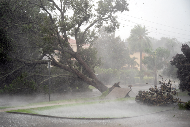
A tree is uprooted by strong winds as Hurricane Ian churns to the south on Wednesday in Sarasota, Florida (AFP photo)
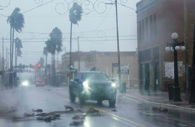
PORT CHARLOTTE, US — Heavy winds and rain pummelled Florida on Wednesday as Hurricane Ian intensified to just shy of the strongest Category 5 level, threatening to wreak "catastrophic" destruction on the southern US state.
Forecasters warned of a looming once-in-a-generation calamity, with life-threatening storm surges, extensive flooding and devastating winds promising what Florida Governor Ron DeSantis called a "nasty" natural disaster.
The National Hurricane Centre (NHC) said in its latest advisory that the "extremely dangerous eyewall of Ian [was] moving onshore" and bringing sustained winds of 155 miles (250 kilometres) per hour, just two mph shy of Category 5 intensity — the strongest on the Saffir-Simpson scale.
Some 2.5 million people were under mandatory evacuation orders in a dozen coastal Florida counties, with voluntary evacuation recommended in several others.
With the golden hour to flee having passed — and hurricane force winds nearly touching south-western Florida — authorities were advising residents to hunker down and stay indoors.
“Ian has strengthened into an extremely dangerous Category 4 hurricane,” the NHC said, warning of “catastrophic storm surge, winds, and flooding”.
Airports in Tampa and Orlando stopped all commercial flights, and some 337,000 households were already without power.
“This is going to be a nasty, nasty day, two days,” DeSantis said.
“It could make landfall as a Category 5, but clearly this is a very powerful major hurricane that’s going to have major impacts.”
With conditions rapidly deteriorating, some thrill-seekers were seen walking in the mud flats of Tampa Bay and in Charlotte Harbor, further south, ahead of Ian’s arrival.
The storm was poised to roar ashore near Fort Myers and Port Charlotte, along the state’s west coast, before moving across central Florida and emerging in the Atlantic Ocean by late Thursday.
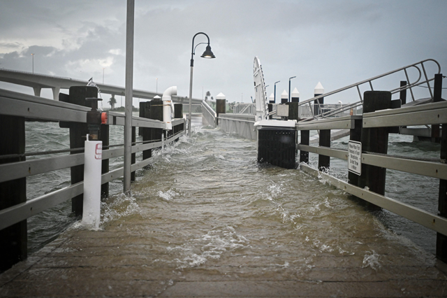
With up to 61 centimetres of rain expected to fall on parts of the so-called Sunshine State, and a storm surge that could reach devastating levels of 3.6 to 5.5 metres above ground, authorities were warning of dire emergency conditions.
“This is a life-threatening situation,” the NHC warned.
Widespread blackout
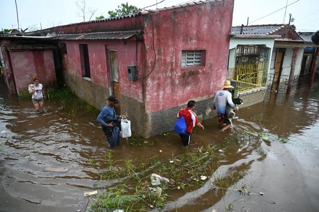
Ian a day earlier had plunged all of Cuba into darkness after battering the country’s west as a Category 3 for more than five hours before moving back out over the Gulf of Mexico.
The storm damaged Cuba’s power network and left the island “without electrical service”, state electricity company Union Electrica said.
Only the few people with gasoline-powered generators had electricity on the island of more than 11 million people.
Others had to make do with flashlights or candles at home, and lit their way with cell phones as they walked the streets.
“Desolation and destruction. These are terrifying hours. Nothing is left here,” a 70-year-old resident of the western city of Pinar del Rio was quoted as saying in a social media post by his journalist son, Lazaro Manuel Alonso.
At least two people died in Pinar del Rio province, Cuban state media reported.
‘Historic event’
In the United States, the Pentagon said 3,200 national guardsmen had been called up in Florida, with another 1,800 on the way.
FEMA (Federal Emergency Management Agency) administrator Deanne Criswell warned that Ian’s “painful impacts” were being felt even before the hurricane’s landfall.
National Weather Service Director Ken Graham echoed concerns about what lies ahead, expressing certainty Ian will leave a trail of destruction.
“This is going to be a storm we talk about for many years to come,” he said. “It’s a historic event.”
As climate change warms the ocean’s surface, the number of powerful tropical storms, or cyclones, with stronger winds and more precipitation is likely to increase.

Related Articles
PUNTA GORDA, United States — Hurricane Ian flooded cities, turned out the lights on millions, and left migrants from an overturned boat miss
STEINHATCHEE, United States — Hurricane Idalia barrelled towards the west coast of Florida on Tuesday, triggering mass evacuation orders and
STEINHATCHEE, United States — Hurricane Idalia slammed into northwest Florida as an "extremely dangerous" Category 3 storm early Wednesday,

Opinion

May 01, 2024

May 01, 2024


Apr 30, 2024
- Popular
- Rated
- Commented
May 01, 2024
Apr 30, 2024
May 01, 2024
Apr 30, 2024


May 01, 2024


Newsletter
Get top stories and blog posts emailed to you each day.