You are here
Archaeologists explore ancient waterway that kept Gerasa fertile
By Saeb Rawashdeh - Jun 26,2022 - Last updated at Jun 26,2022
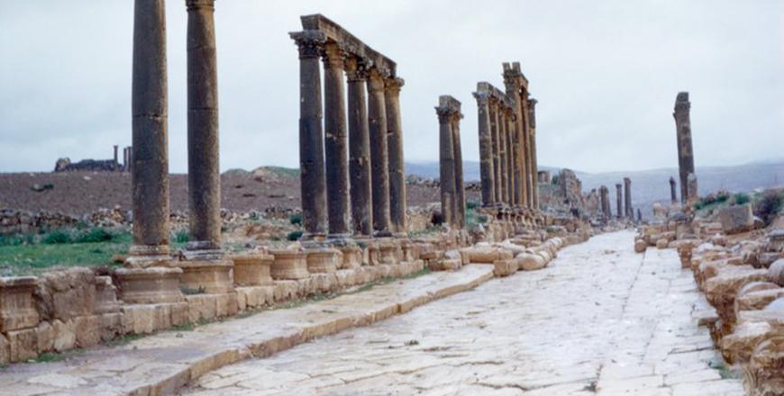
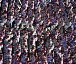
The Collonaded Street in Jerash, some 48km north of Amman (Photo courtesy of ACOR/George Bass Collection)
AMMAN — Roman Gerasa (Jerash) was divided by the steep Wadi Jerash in a north-south direction and in Antiquity it was called the “Gold River”, the Chrysorrhoas, according to an archaeologist.
The eastern part today is mostly covered by the modern town of Jerash, while the western part is an archaeological zone, and numerous public monuments of the Roman, Byzantine and early Islamic periods have been excavated, said Professor of Classical Archaeology from Aarhus University Rubina Raja.
She said that the River Chrysorrhoas has its origin in the village Suf, approximately seven kilometres northwest of Jerash.
“The Chrysorrhoas is a tributary to the River Zarqa [Jabbok] into which it flows approximately five kilometres south of Jerash. The springs at Suf play a crucial role for the water supply of Gerasa. On the one hand, these springs feed the river, and its water was used for all kinds of irrigation and water-supply purposes of the city. On the other hand, water channels starting at Suf and in the wadi upstream supplied Jerash directly with fresh, running water,” Raja told The Jordan Times in an email interview.
Meanwhile, Professor Achim Lichtenberger from University of Münster said that the upper part of the Chrysorrhoas between Jerash and Suf is fertile even today and has been used for intensive agriculture over time.
“From the Roman period, we even know of an association of the ‘gardeners of the upper valley’,” he said, hinting at the profound impact the river had on social formations and groupings within the city.
Touching on the river’s cultic and religious relevance in ancient times, Lichtenberger said among the marble sculptures of the city, a small statuette of a reclining river god is attested, hinting at cultic veneration of the river in the shape of a deity in the city.
The river and its supply for domestic use had immense impact on the city’s urban layout, he continued, adding that since the river cut the city into two, these halves had to be bridged by several bridges that connected the western side with the eastern.
“The river also had to be integrated into the Roman city walls, and at least at the southern exit of the city a water gate was located, specifically constructed for letting the river’s water out of the city,” Raja said.
Due to all the mentioned aspects of the relationship between the river and the settlement, it is obvious that the river had a strong impact on the settlement’s life, Raja said, adding that today, the river also serves as an archive for the settlement’s biography.
Furthermore, the sediment profiles tell the story of the region and provides information about the history of the city, Lichtenberger said, adding that throughout the course of the wadi, thick sequences of river and slope deposits, formed during the ice age and the early Holocene, are found.
“These soils retain no traces of human activities, but anthropogenic activities [pollutants] in the landscape and inside the city and these sediments and soils retain numerous artefacts, in particular ancient pottery, which have been washed out of the city,” Lichtenberger said.
According to Raja, the first analysis of the red Mediterranean soils from within the city suggest that, at some stage since the Roman period, a more arid climate prevailed in Jerash.
“Hence, studies of both the wadi’s records and the debris within the city can be used to test and challenge the narratives about Jerash’s development and demise, while at the same time providing new insight into natural changes in water-supply potentials and food security, which were two of the most basic factors for ensuring survival of urban life,” Raja concluded.

Related Articles
AMMAN — The quarter close to Temple of Artemis in northwestern part of ancient Gerasa (Jerash) has not been explored enough in the past, so
AMMAN — From the Roman period to Early Islamic times, Jerash had a “strong and continuous” pottery production, according to two scholars who
AMMAN — The settlement in Jerash (Gerasa) during the Middle Islamic period was much more extensive and complex than hitherto thought, said a

Opinion


Apr 24, 2025

Apr 24, 2025
- Popular
- Rated
- Commented
Apr 24, 2025

Newsletter
Get top stories and blog posts emailed to you each day.