You are here
Holy Land in archive of Hisham Khatib
By Saeb Rawashdeh - Nov 13,2022 - Last updated at Nov 13,2022
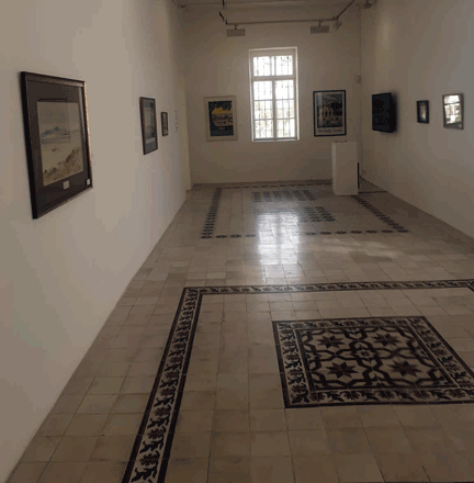
Paintings from the collection of Hisham Khatib exhibited at Darat Al Funun main building on November 7 (Photo of Saeb Rawashdeh)
AMMAN — Hisham Khatib was a Renaissance man — an expert in energy, economy, art history and political history of the Levant. He combined a cold, scientific part of his personality with his love for paintings, historical maps, manuscripts, atlases and old photographs from the Holy Land.
Born in Acre in 1936 and raised in Acre and Jerusalem, he studied Electrical Engineering and Economy, but Khatib was also an avid art collector and erudite specialised in the Ottoman Palestine, Jordan and Egypt. Despite his public posts as minister of Energy and Natural Resources, minister of Planning, minister of Water, director of the Jerusalem Electric Company and vice president of the Jordanian Water Authority, he devoted time and energy to study collections of art works created by Western travellers and Orientalists who began to flock the region in the 19thcentury and the early 20th century.
For decades, Khatib transformed his home into a museum of oil paintings and aquarelles that depict historical sites and sceneries in Palestine under the Ottoman rule. Some of his collections of vintage historical maps and manuscripts represent rarities in the region. It won’t be an exaggeration to say that his private art collection, which he meticulously arranged, is one of the biggest dedicated to the Ottoman Levant.
From October 25th until January 31st 2023, under the title” Topography of Place-Palestine and Jordan-Homage to DrHisham Al Khatib: The Collector and the Archive”, a part of this extraordinary historical treasure will be exhibited at Darat Al Funun whose honorary member Khatib was for many years. Over there the visitors could contemplate over towns and villages of the Ottoman Palestine, Jordan and Egypt with its everyday noise, markets and temples.
Some cartographers like Pierre Jacotin, who came with Napoleon’s army to Egypt and Palestine in 1798, left valuable scientific records in his atlas. Jacopin’s description of Egypt is one of the best geographic works in the 19th century about southern Levant.
What highlights Jacopin’s atlas is that he used hachures to show relief of Egypt, Sudan, Libya and Palestine.
Another work “Jerusalem the Holy City [HierosolymaUrbs sancta]” by Georg Braun and Franz Hogenberg depicts the walled Jerusalem and Ottoman officials chatting.
Before the period of Tanzimat (Reform of the Ottoman Empire) in 1839-1878 travelling to Palestine was very hazardous because of robbers so most explorers preferred to stay within protective walls of cities instead of roaming around the hinterland. However, most of the early scholars were motivated by Biblical stories and they tended to find the proof for these narratives.
Khatib’s books “Palestine and Egypt under Ottomans: Paintings, Books, Photographs, Maps and Manuscripts”, published in 2003 and “Jerusalem, Palestine and Jordan: Images of the Holy Land”, published in 2013-remain a testimony from the period of the Ottoman rule of this area as well as an evidence of the exceptional zeal that intellectual Khatib possessed.

Related Articles
AMMAN — Although Hisham Khatib has a career spanning 50 years in the energy sector, the former minister has also found the time to dedicate

AMMAN — The former minister of water, energy and planning Hisham Khatib is also a collector of historical maps, manuscripts, photographs and
Falastin Al Hadara ‘abr Al Tarikh — Palestinian Civilisation throughout HistoryTranslated from the Arabic by Joud Halawani Al TamimiAmman: T

Opinion

Apr 21, 2025

Apr 21, 2025

Apr 21, 2025
Apr 21, 2025
- Popular
- Rated
- Commented
Apr 20, 2025
Apr 20, 2025
Apr 19, 2025


Newsletter
Get top stories and blog posts emailed to you each day.