You are here
Umm Tuwayrat excavations reveal Bronze Age funerary practices
By Saeb Rawashdeh - Feb 22,2025 - Last updated at Feb 22,2025
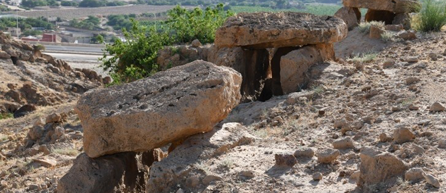
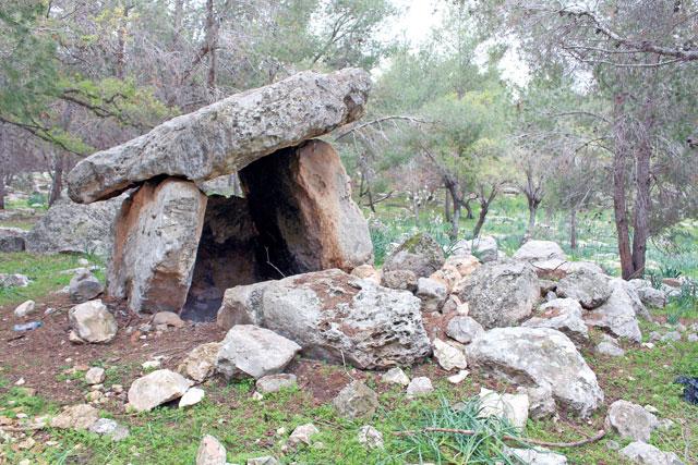
A dolmen near Umm Tuwayrat, near Shobak in southern Jordan (Photo courtesy of Jordan Dolmens)
AMMAN — The Umm Tuwayrat site is a dolmen field probably related to the Bronze Age located near the city of Shobak. The site was first documented by Elżbieta Dubis, Mohammad Marahleh, and Sami Nawafleh in 2004.
Jagiellonian University (JU) team included preparing a detailed geological map of the site’s geological stratigraphy and lithology and the geological layers at this site span from the Late Cretaceous to the Palaeocene.
To the east and west, the natural boundaries of the site were the valleys of two seasonal rivers.
However, several stone structures identified during their search appear to be fragments of two stone walls that probably constituted the original symbolic boundaries of the site from the south and north, noted Marek Novak from JU, adding that within these borders were other stone structures including 12 dolmens and at least 10 stone circles or mounds.
"The function of stone mounds and circles is often difficult to identify. Similar stone circles found throughout the Near East have been linked to a variety of activities [e.g. agricultural, cultic, funerary, land marking]," Novak said.
"However, the rocky nature of the Umm Tuwayrat site makes it unsuitable for agriculture, therefore this activity can be ruled out as the original context of the stone structures," Novak underlined.
He added that due to the funerary nature of the site, the stone circles were used in rituals or during preparation of corpses prior to secondary burial in the dolmens.
Six out of 12 dolmens were well preserved, while the remaining dolmens were damaged. The structures reached up to 160 cm in height, 200 cm in width, and
300 cm in length, Novak said, adding that the goal of the fieldwork was to comprehensively document the structures and all the artefacts scattered on the surface in their vicinity, as well as to methodically explore the soil pockets and hollows around and inside the dolmens.
The Polish team identified deposits resulting mostly from natural erosion processes, especially in the sloping part of the site. Only dolmen contained a thin soil layer that seemed to constitute the primary archaeological context for the artifacts and the deposited human remains.
"In this context, the bones were found folded in a non-anatomical position, piled up inside the dolmen along one of its walls. In addition, several unidentified structures have been found at the site, the most intriguing being a rectangular pool and a well carved into the rock at the top of the hill," said Jacek Karmowski.
Karmowski added that the chronological relationship between these structures and the dolmens remains elusive, and the pool and well may have been built at a later date.
It remains unknown when dolmens were created.
In general, little can be said about this assemblage beyond the fact that pottery fragments, ranging from the Chalcolithic/Early Bronze Age to the Byzantine period, were found near the dolmens and in their interiors.
"The research brought to light 608 artefacts made of siliceous rock scattered among the dolmens. The majority, e.g. flakes and blades were difficult to assign to precise cultural or chronological groups, although some specimens appeared to be associated with the Bronze Age and, possibly, with the Late Neolithic and Chalcolithic," Karmowski elaborated.
These included flakes with steep or semi-steep retouches on the edges transverse to the débitage axis and minor retouches on the sides, classified as inserts or sickle.
The latter are considered to be more characteristic of the EB I, but they also occurred in Chalcolithic assemblages, although in smaller numbers.
Only one unmistakable example of a tabular scraper was found but numerous flake tools of a similar type, commonly referred to as scrapers were present as well. Notably, the forms mentioned here have also been recorded in Neolithic contexts.
"However, given the other finds at the site, including structures and pottery, these tools should be attributed to the Chalcolithic or the Bronze Age," Novak underscored, adding that the lithic assemblage also contained core bifacial tools, which rather seem attributable to the Chalcolithic.

Related Articles

AMMAN — A menhir is an upright stone that can be found across the globe: Middle East, Europe, Africa, South America and Asia.
AMMAN — Dolmens, above-ground tombs made of giant slabs of stone, are scattered throughout northwest Jordan, but their absence from other ar
AMMAN — High above the Zarqa River, the mountaintop ‘Temple of the Serpents’ gives clues to the development of human communities during the

Opinion

May 18, 2025

May 18, 2025

- Popular
- Rated
- Commented
May 18, 2025
May 18, 2025


Newsletter
Get top stories and blog posts emailed to you each day.