You are here
Settlements of Jebel Qurma: Uncovering Jordan’s ancient desert dwellings
By Saeb Rawashdeh - Mar 12,2025 - Last updated at Mar 12,2025
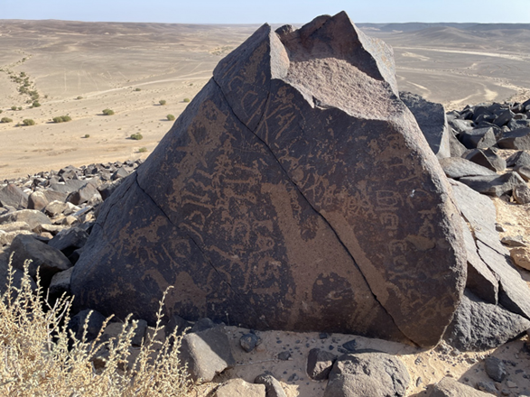
The Jabel Qurma range contains thousands of petroglyphs accompanied with safaitic script (Photo courtesy of Jabel Qurma Archaeological Landscape Project)
AMMAN — In northeastern Jordan, the rough and rocky Harra begins about 30 kilometres east of the small oasis town of Azraq. This basalt desert has been a home to different settlements and was occupied from the time immemorial.
“The Black Desert is characterised by basalt-capped table-mounds and plateaus that alternate with extensive gravel plains, mud flats of varying size, and low limestone ranges,” noted Merel Bruning from Leiden University.
Bruning added that the hyper-arid and difficult-to-cross uplands have an average annual precipitation of less than 50 mm and are known as Jabel Qurma.
"It is named after the prominent mound at the south-western edge of the Harra expanse, where Wadi Rajil debouches out of the basalt into the Hazimah plain. The site of QUR-595 is situated on small and low limestone hillock measuring about 45 m long, 20 m wide and 1–1.5 m high," said Bruning.
The researcher added that it lies at the northern foot of the mound of Jebel Qurma and directly along one branch of Wadi Rajil.
“The 2013 survey and 2015 excavation at the site were carried out as part of the Jabel Qurma Archaeological Landscape Project, which seeks to address local settlement and quotidian activities from a multi-disciplinary and multi-period perspective, and investigates how these relate to the diverse landscapes and environment,” said the professor Peter Akkermans from Leiden University.
Akkermans added that the project takes place under the auspices of the Faculty of Archaeology of Leiden University, and in close collaboration with the Department of Antiquities of Jordan.
"The excavation in 2015 made clear that the site had three [possibly four] roughly round or oval-shaped, stone-walled installations built against each other at the top of the limestone hillock. These structures are named A to D in this contribution for matters of convenience," Akkermans noted.
"It seems that Structures A and B were constructed first as free-standing structures, with the smaller Structures C and D added afterwards," Akkermans underlined, noting that the buildings range in diameter from about 5.6 m (Structure A), to 5.9 m (Structure B), and 1.7/1.3 m (Structure C).
Less clear is the outline of Structure D, although its stone concentrations suggest some irregular walling: This comprises an area about 2.3 by 1.3 m, Akkermans underlined.
The professor noted that each structure was bounded by low (maximum 40 cm tall) and wide (between 40 and 80 cm) walls, which consisted merely of loosely piled heaps of basalt rocks, the outlines of which were often difficult to establish.
"In general, the amount of basalt stones uncovered in and around the structures is too limited to account for any substantially raised walls."
"The only undisputed remains of walling were found on the north side of Structure A, in the form of a relatively narrow wall made of basalt blocks carefully stacked up to three courses high [ca. 40 cm]," Akkermans said.
However, it is highly likely that this wall is a (much) later addition to Structure A, not only because of its better state of preservation, but also because it seems to block the original entrance to the structure, Bruning said.
Structures A and B were originally accessible through openings in their northern walls, while the later Structures C and D had passages in the south-east (C) and south (D), Bruning continued, adding that none of the buildings preserved evidence for intentionally made floors or any form of roofing.
"Most likely the low structures were simply open to the elements or they had superstructures made of perishable materials [such as hides or brushes]," Bruning concluded.

Related Articles

AMMAN — The researchers who worked in the Black Desert found poorly preserved skeletal remains of a human, who apparently had been buried in

AMMAN — The Jabal Qurma Archaeological Landscape Project started in 2012, with extensive field surveys and excavations in the basalt desert

AMMAN — Recent fieldwork at the vast desert region in north-eastern Jordan has revealed an immensely rich heritage of an area that is diffic

Opinion


Apr 12, 2025

Apr 12, 2025
- Popular
- Rated
- Commented
Apr 12, 2025
Apr 12, 2025


Newsletter
Get top stories and blog posts emailed to you each day.