


 Share Story


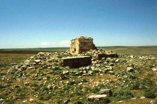
AMMAN — The French nobleman, archaeologist and orientalist Louis Felicien de Saulcy(1807-1880) left the first detailed account about Khirbat Faris, a site on the Karak Plateau, with ceramics from the Nabataean and Middle Islamic periods. Saulsy visited the site in 1851 while in 1896 Alois Musil(1868-1944) described the site as “ a well preserved tower and ruined houses”. The American scholar Nelson Glueck (1900-1971) also studied the site of Khirbat Faris.
“Two ruined buildings plus the traces of a third are again recorded, as well as the ‘wall lines of numerous structures … [and] cisterns among the wall remains’ and the tomb. The ceramics collected during the survey ranged from the Middle Bronze Age I to the Late Islamic,” noted Glueck.
During his visit in 1851, de Saulcy describes “a small circular hillock” that he interpreted as a ruin of a Byzantine church from 7th -8th centuries AD.
“A recent clandestine excavation has revealed a large Corinthian capital and an architrave block, both in limestone. Late Roman and Byzantine sherds were recovered from the site and our own collection added a sherd of Umayyad red-on-grey painted ware to the assemblage. Moreover, in 1988, further Umayyad pottery was collected from Khirbat Faris,” said Professor Andrew Peterson.
Khirbat Faris lies in rich wheat and barley agricultural land. Grain, legumes, tomatoes, grapes and summer crops are cultivated on the plateau, noted Peterson, adding that raising sheep, goats and cattle complement this agriculture.
“By the 1stcentury AD, the inhabitants of Khirbat Faris were Nabatean subjects using distinctive Nabatean wares and worshipping at the nearby temple of Al Qasr. There seems to have been a ‘dynamic evolution’ in Nabatean material culture at this time as evidenced by archaeological work in the larger centres of Nabataea e.g. Petra, Huwara [Humayma] and Ayla [Aqaba],” Peterson underlined, adding that the construction of the waystation at Khirbat Faris may well fit into this resurgence.
Vital communication and trading routes were close to Khirbat Faris, particularly “The King’s Highway”.
However, the prosperity and stability of this time continued as Nabataea was annexed by the Roman Empire in 106 AD.
“Khirbat Faris then fell within the administrative province of Arabia, with its capital at Petra. The administrative change that this brought to a provincial village was probably minimal,” Peterson said. The employment and trading opportunities brought to the population of Khirbat Faris by the upgrading of the King’s Highway to the Via Nova Traiana and the construction of the Limes forts.
The ancient geographer Claudius Ptolemy (100 AD-170 AD) mentions Karak and Al Rabba in his “Geography”.
“It is the 6th –8th centuries AD that allow more extensive characterisation of the occupation at Khirbat Faris. Arguably, at this time, the whole site was known as Khirbat Tadun and was a flourishing village within the Byzantine administrative district, first of Arabia and then Palestine III with its capital at Petra,”said Alison McQuitty who is a co-director of Khirbar Faris project.
Throughout Jordan, the Byzantine period is seen as a peak of agricultural occupation and use of the land, McQuitty continued, adding that there was at least one church at Khirbat Faris, and maybe two, judging by the objects found in the trenches, as well as the analysis of the Tadun’s name.
“The clergy would have answered to the bishop in nearby Areopolis [Al Rabba], who himself would have answered to the metropolitan bishop of Petra,” McQuitty stressed, adding that in subsequent centuries, the settlement at Khirbat Faris, administratively, continued to be oriented southwards.
